 |
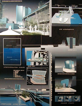
Topographical Shadows
A layered system of landscape, circulation, and program.
Lot 76 is a dynamic site that integrates major through ways for vehicular circulation as well as being adjacent to popular pedestrian paths and parks. By analyzing these systems a complex overlapping, or layered, system emerges where each respective area of motion intersects accordingly. These juxtaposed systems form ‘shadows’ at areas of intersection and connection, suggesting new possibilities for a new topography. This proposal integrates a new topography with new systems of program and circulation, creating a dynamic landscape that layers harmoniously with the existing conditions. Please keep in mind that the process described below was not necessarily done in a 1 – 2 fashion, but rather as a reactive process where one piece would influence another, and vice versus.
Step 01: Site Analysis
Our strategy began with an analysis of the existing circulation patterns to fully understand how the site was used and what areas could benefit and/or be used to promote a stronger sense of community and interaction. We did this by diagramming the existing circulation, both pedestrian and vehicular in a 3 step process.
Site Diagram 1: Explores how these existing conditions overlap and influence each other. This gave us a foundation to build on, including areas or ‘shadows’ on multilevel circulation. An example would be an overpass/underpass relationship. We also began to question these shadows and there potential to inform a development of the topographical conditions. Site Diagram 2: Illustrates these shadow areas and the potential for further juxtaposing the layers of pedestrian and vehicular circulation to allow for a great diversity of topographical conditions to emerge.
Site Diagram 3: Shows the topography with a developed landscape, including circulation throughout. This landscaping was defined by planters, pools and pavilions.
Building Design
The building design began with understanding the requirements of the program, both in the given square footage and the inherent necessities of the function. We looked at how we could integrate the building on as many levels as possible with the surrounding community. To accomplish this we addressed the topography of the site with its many physical layers and our initial site diagrams. We concluded that we could integrate the community on several layers. Our building design is fundamentally made up of the following characteristics:
Site
The first interaction with the site occurs along the street front(s). We created a café/shop area along the Burnside street façade to encourage pedestrians to stop and enjoy. This area leads South into a passageway that leads underground and out onto the new landscape, again encouraging pedestrians to engage the new design. This directionality is carried out all the way down to the Willamette River, potentially creating a dynamic park for the community to enjoy.
The second area of interaction is the pedestrian bridge. We observed that the way the site falls off towards the water and Burnside continues upwards and over the River could be utilized in a productive way. By creating a bridge we allow for pedestrians to access the landscape on a multitude of levels. This begins within the building’s lobby and emerges on the South facade, immediately connecting with a bridge from Burnside and continuing down to the waterfront with several areas of connection, both vertically and horizontally, to the landscape. The third area of interaction is the rooftop restaurant. We strategically manipulated the floor plates to allow for an asymmetrical section. This allowed 3 floors (42’) on the Eastern half of the building to be used for an indoor/outdoor restaurant. It was significant, in our opinion, to address the heritage of signage the Lower Burnside has as well as creating an icon that could be seen from the rest of Portland. This would be the final relationship between the community and the new building.
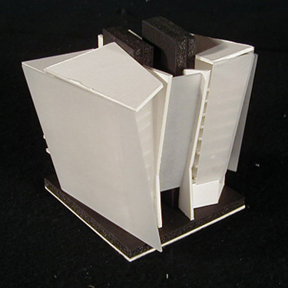
Facade and Form
We took a similar approach to the form and facade as we did to the site. We were interested in investigating ways of overlapping and creating ‘shadows’ with the pieces that would form the building. This generated a dynamic building that addresses specific characteristics of the site. The North facade is rectangular and minimal, addressing the planar edges of the existing buildings. The South facade is made up of layered glass, broken up into programmatic pieces. We were careful to form a termination point just above street level. This ensured that the building would address the street and pedestrians in a unique and appropriate way, as opposed to the free flowing glass planes of the upper portion.
Integration
Finally, we worked with the complete integration of site, building, and landscape to form a harmonious relationship that could develop and evolve with the community. We have suggested that residential areas be developed alongside the park, to further this new community. The park pavilions could be expanded to include light retail, the park extended, circulation extended, etc.
Conclusion
This strategy demonstrates a way to develop the required program, proposed residential, and areas of recreation while providing a solution to be carried out throughout the Burnside area. This new dynamic integration will allow for lower Burnside to develop as the area dictates, generating a promising future.
|